BY STEFANIE JACKSON, Eastern Shore Post —Since Virginia was first colonized in the 1600s, it has lost around 45% to 50% of its wetlands, and nonprofits like The Nature Conservancy are striving to save what remains.
Since 1995, the conservancy, a global nonprofit organization with land holdings on the Eastern Shore, has preserved and restored thousands of acres of wetlands in Virginia through the Virginia Aquatic Resources Trust Fund.
On the Eastern Shore, the conservancy maintains two restored wetlands sites: Level Ponds, near Parksley in Accomack County, and the new Custis site on U.S. Route 13 near Exmore in Northampton County.
Level Ponds, on the bayside, is approximately 12 years old and was created to offset the impact to non-tidal wetlands from the construction of Walmart in Onley.
The Custis site, on the seaside, was built to offset development in the Atlantic Ocean Basin, which includes parts of Virginia Beach in addition to Accomack and Northampton counties.
Nontidal wetlands
Most people are familiar with tidal wetlands like the salt marshes that are common across the Shore, but both of the conservancy’s local mitigation projects are nontidal wetlands.
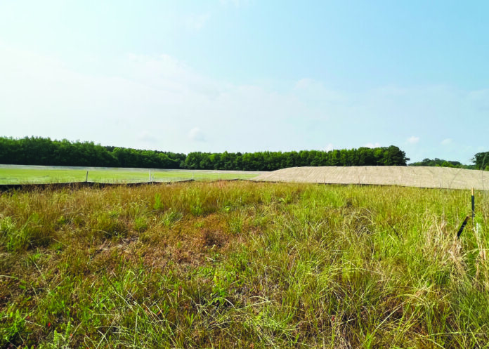
Nontidal wetlands often appear similar to other areas of land, especially during the dry season when they may have no standing water.
Wetlands, whether tidal or non-tidal, must meet three criteria: they must have the correct types of soils, plants, and hydrology.
A nontidal wetland cannot be identified simply by observation. The soils must be studied and identified by color and the land must remain inundated by water for at least 28 days during the growing season.
Despite its name, a nontidal wetland can appear completely dry, especially in the summer, but will often have standing water during the winter.
Project types
When construction will impact existing wetlands, state and federal agencies will require a plan to mitigate those impacts before issuing permits.
One option is for the developer to purchase offset credits from a wetland mitigation bank. One credit equals one acre of wetlands. The number of credits needed depends on the number of acres of wetlands impacted by the construction project.
A wetland mitigation bank first restores or builds wetlands and then sells the credits.
A second option is to purchase “advance credits” from an in-lieu fee program, so named because developers are paying others to perform the mitigation in lieu of doing the work themselves.
The offsets are called advance credits because they are sold before wetlands are restored or built. When the targeted mitigation project is complete, the credits are released.
TNC’s Virginia Aquatic Resources Trust Fund is an example of an in-lieu fee program.
A third option is called permittee-responsible, in which the permitted parties, whether large firms or private individuals, are responsible for the wetlands mitigation.
This can be “incredibly more costly and time consuming … and often less desirable or ecologically successful for the wetland resource,” said Karen Johnson, the conservancy’s director of wetland and stream mitigation.
Constructing wetlands
How does one construct wetlands? Through science, said Kati Booth, the conservancy’s wetland restoration specialist.
Humans can’t perfectly replicate nature, but by applying science, they can plant and grow a functional wetland.
Those qualified to construct wetlands are called “wetland engineers,” said Johnson.
Wetlands engineers can be professional engineers, professional wetlands scientists, environmental scientists, biologists, ecologists, hydrologists, and geologists.
Choosing the project site
Farmer Phil Custis contacted the conservancy about a field he owned that was too wet to be productive enough to turn a profit.
The field was wetlands about 100 years ago and contained the hydric soils needed to support wetlands.
Level Ponds also was previously farmland and it is not uncommon for farms to be used as wetlands mitigation sites.
However, active farmland, which on the Shore often consists of bojac soils, is not desirable for conversion to a wetland.
Former farmland containing bojac soils that have been sterilized through saltwater intrusion could be possibilities for wetlands conversion, but wet soils like the nimmo at the Custis site are preferable.
The terms “construction” and “wetlands” may not sound like they go together, but converting a farm field back into a wetland is similar to a construction project.
Like a construction project for a school, office building, store, or restaurant, a wetlands mitigation project is designed and engineered by professionals.
Private company Resource Environmental Solutions was the engineer for the Custis site. The company is a wetland mitigation banker but did not work on the Custis project in that capacity.
A map of the site is drawn and includes a “planting palette,” a chart of all the species of grasses, shrubs, and trees to be planted and the number of each to be planted.
Heavy equipment was brought to the Custis site to remove the topsoil, dig down about 1.5 feet to reach groundwater level, and then replace the topsoil.
The spoils were used to build a seven-acre berm around the site. The berm prevents “hydrologic trespass,” which is wetting or flooding adjacent properties that are not part of the mitigation project.
More than a dozen species of wetland and upland trees and shrubs were planted, including loblolly pine, willow oak, red maple, blackgum, and persimmon.
Both wetland and upland herbaceous seed mixes were planted, including grasses such as Indiangrass and Virginia wild rye and flowers like common milkweed and blackeyed susan.
The site also was designed with several depressional ponds that will fill with water and attract shorebirds and other wildlife.
Community benefits
Kelley Galownia, the conservancy’s media relations manager, said wetlands mitigation sites benefit not just developers but the entire community by protecting both property and the drinking water supply.
The idea that property near wetlands is at increased risk of flooding is a misconception, Galownia said.
Wetlands protect property from flooding by acting as sponges that soak up and hold rainwater.
Wetlands also filter the water that flows into rivers and streams. More wetlands mean cleaner drinking water.
Conservancy’s role
The Virginia Aquatic Resources Trust Fund is administered through a partnership of the conservancy, the Virginia Department of Environmental Quality, and the U.S. Army Corps of Engineers Norfolk District.
DEQ and the corps of engineers are involved in permitting and regulations, but the conservancy’s focus is on the location, design, construction, and management of the wetlands mitigation sites.
As a nonprofit, the conservancy does not pocket any leftover funds from a wetlands mitigation project. The money is returned to the aquatic resources trust fund, which is monitored closely, like a grant.
The Custis site is a 26-acre parcel worth 18 offset credits. Each credit costs $100,000, for a total value of $1.8 million.
The conservancy has spent more than $1 million constructing the Custis site and over the 10-year monitoring period will replant native species and remove invasive species as necessary.
The conservancy will ensure the wetlands are protected through a Virginia Eastern Shore Land Trust conservation easement.
For more information, visit www.nature.org/vartf


