By Carol Vaughn —
Gov. Ralph Northam in December announced the release of Virginia’s first coastal resilience master plan, saying the plan will guide decisions by the state and local governments to try to protect Virginia’s coast.
“We must acknowledge that climate change is permanently altering the physical limits of our coastal lands,” said Northam, adding, “The only way we can adapt and maintain our thriving communities is with thoughtful planning, reliance on science, and a willingness to make tough decisions.”
The Coastal Resilience Master Plan, Phase 1, was developed with help from 2,000 stakeholders, according to a press release.
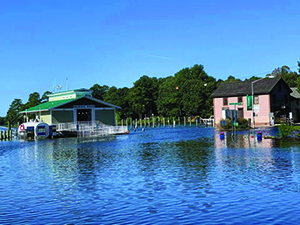
The plan documents which areas are exposed to coastal flooding now and makes projections into the future.
Northam in a Dec. 7 letter announcing the plan’s completion said it involved a nearly four-year process.
“I was raised on the Eastern Shore — this is personal to me — and I know our coastal communities are already struggling with the consequences of climate change, and that the best science predicts that conditions will worsen in the coming years,” he wrote, adding that, with the plan, Virginia now has “a clearer picture of the scope and scale of the challenges facing the Commonwealth.”
According to Northam, the science behind the plan “also shows definitively that some communities and facilities in Virginia will cease to be habitable or accessible over the next 60 years” due to frequent flooding, catastrophic events, or permanent inundation.
While the plan identifies critical structures that should be protected where they are, “it is clear that we must also focus on the most important and effective flood protection measure of all: moving people and structures out of harm’s way,” Northam said in the letter.
Almost 6 million people, 70% of the state’s population, live in coastal Virginia.
The plan says that between 2020 and 2080, the number of Virginia residents in homes exposed to extreme coastal flooding is projected to grow from around 360,000 to 943,000.
Additionally, the number of buildings exposed to extreme coastal flooding is projected to rise by nearly 150%, from 140,000 in 2020 to 340,000 in 2080; the annual cost of flood damage kn the region is expected to increase by 1,300%, from $400 million to $5.1 billion.
Miles of roads exposed to chronic coastal flooding is projected to increase from 1,000 to nearly 3,800 in the period.
Additionally, around 170,000 acres, or 89%, of tidal wetlands in Virginia and 3,800 acres, of 38%, of existing dunes and beaches may be permanently inundated by 2080, according to the plan.
One outcome of the plan is an online database, available to the public at https://www.dcr.virginia.gov/crmp/plan (click on Coastal Resilience Web Explorer link), where the impact of flood hazards, current and proposed resilience projects, and funding sources may be viewed for specific localities.
“This work is the culmination of a significant collaborative effort on the part of stakeholders across coastal Virginia, and in particular, the Technical Advisory Committee (TAC), who advised us during this process,” said Rear Admiral (Retired) Ann C. Phillips, Special Assistant to the Governor for Coastal Adaptation and Protection.
Northam established the TAC via Executive Order 71, issued in November 2020.
The committee includes representatives of state agencies, the eight coastal Virginia planning district commissions, and regional commissions, along with academic advisors and others.
“The TAC, and seven TAC Subcommittees, including Agency Directors and Commissioners, Academia, the eight Coastal Planning District and Regional Commission Directors, USACE, DoD and other Federal partners, Tribal Representatives, NGOs and other invited stakeholders, worked tirelessly this year. We are deeply grateful for their continued support and advice to adapt and protect Coastal Virginia,” Phillips said.
Mark Luckenbach, Associate Dean of Research and Advisory Service at the Virginia Institute of Marine Science, said a strength of the plan “is its reliance on science.”
“Members of the Technical Advisory Committee drawn from Virginia institutions of higher education helped ensure that the plan was informed by state-of-the-art science, as well as policy and legal reviews. As the Commonwealth moves forward with implementing and updating the plan, Virginia’s universities are poised to provide data, analyses, and expertise on wide-ranging topics that will be essential to its success,” he said.
The intention is to update the master plan at least every five years. Updates will be managed by the Virginia Department of Conservation and Recreation in consultation with the Chief Resilience Officer, the Special Assistant to the Governor for Coastal Adaptation and Protection, and the Technical Advisory Committee.
The plan’s next phase, expected to be completed by 2024, will include analysis of additional flooding hazards, including rainfall-driven, river, and compound flooding along with coastal flooding, following the TAC’s recommendations.
Skip Stiles, Wetlands Watch executive director, said the plan “gives Virginia its first strategic approach to dealing with sea level rise.”
Northam said future versions of the master plan “will continue to identify and prioritize adaptation strategies that are realistic, not wishful.”
Coastal Virginia is second only to New Orleans in being the region of the United States most threatened by sea level rise and flooding resulting from climate change, according to scientists.


